I started to write a post yesterday, about Natural Sequence Farming, and wondered if it would be insensitive to post, due to the flooding people are currently experiencing. After all, Peter Andrew's revolutionary way of farming in Australia, uses natural sequences. Specifically, how our land traditionally hydrates itself.
As the classic poem, "My Country", by Dorathea Mackeller says:
"I love a sunburnt country,
A land of sweeping plains,
Of ragged mountain ranges,
Of droughts and flooding rains."
That is our natural sequence...of droughts and flooding rains. I will publish my post in the interests of learning about the forces which shape our landscape. First, a picture of what we started with, back in 2006. A huge sandpit. Or as Peter Andrew's would term it - a recharge area.
Visiting the property before the house was built
I learned about Natural Sequence Farming, after watching the ABC's Australian Story documentary, on how Peter Andrew's managed to hydrate his horse property, through one of Australia's recent droughts. Then I read his two books, "Back from the Brink", and, "Beyond the Brink. It opened my eyes to the unique sequences, which were already happening on our property.
Andrew's work, centres around water hydrology, first and foremost. Without water, Australia would be more of a desert than we already are. I hope to demonstrate how Peter Andrew's hydrology opportunities work, due to the interventions we've made on our property:
Upstream, of the sandpit - other end of property
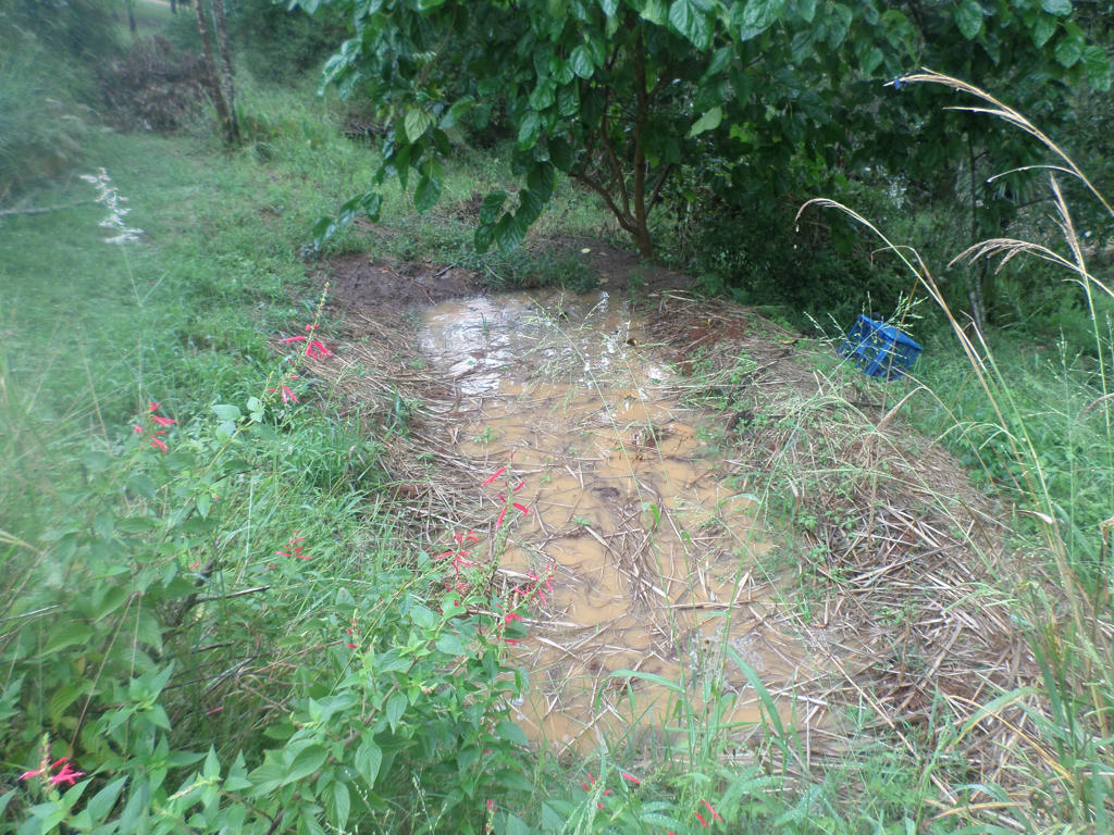
Thanks to the generous rain which has fallen lately, it's easy to capture the effects of blocking our waterway with organic debris. We mostly use smaller branches and leaves, with a few larger ones to help lock it together. Like a beaver dam, but not as expertly built!
The path of water hits the debris plug, causing it to back up, then escapes again, on either side. With each rain event, more debris gets caught from upstream. Silt starts to be dropped behind, and eventually creates a plateau, rather than a deep channel. Somewhat like a natural swale.
Important to note from the above image, is how the water is now split into 3 different forces. Straight through (what does manage to get through) and overflow out both sides.
In miniature
In the image above, you can see on a smaller scale, where the water is being held up, in various stages of debris too. This is the main channel, where the water flows the slowest, due to the debris it passes through first.
Notice how the larger body of water is held back by the debris, forcing it to spread out. It overflows at the lowest point in the debris - generally in the middle. Then another pond, smaller than the last is formed, in exactly the same way. This process continues for as long as the water is held up, and there is water to escape. It's a slow and steady release of water.
The aim is all about diffusing the power and velocity behind water. Because with that power, comes erosion. Andrew's theory is, and the evidence of ancient aboriginal paintings (series of connected circles) demonstrate that, water flowed and was stored in an extensive, connected pond system. Not like the traditional, European rivers - which tend to be singular, wide and deep; with the fastest route to the ocean.
Three different routes of travel
A little further past the debris plug, is how these three different levels of water, act differently. Andrews spoke of how water flowed on the high ground. Which is exactly what happens with our gully, thanks to our interventions.
The main channel flows the slowest, because it acts like a swale. It fills completely and stays still, until the water level finds a small overflow point. Most of the high velocity water, however, is escaping quicker on both sides. So it's flowing the fastest, on the high ground.
Which seems counter intuitive, but that's how levels of water work. The greater the water being held back, the higher up, the water will flow to escape.
All pictures taken, after the rain stopped
and the water levels dropped
So where is the fast water running to? It has found a gentle slope, away from the main channel. This is our people traffic route, and no doubt, what the kangaroos use also. We tend to keep it clear of debris, so we can access it. We're just another group of animals, nature uses to create paths for water to travel.
This water is travelling towards a pond we strategically built, to capture this periodic bounty. Of course, the flow met a few obstacles on the way, with another nod to Peter's Andrews interpretation of the landscape.
Old tree stump
Andrews recommends, that tough trees be planted in waterways, to make the water divert around them. It splits the water in two, then collides at the other end. Which effectively, neutralises the two forces against each other. Slow rising water, it better than fast.
This was not a tree we planted. It was a natural bounty, as a result of a former bushfire. It was burnt out and the land developers must have scraped up the top half, and burned it before we purchased the land. Because we've seen hide nor hair of it, since. The blackened, hollowed out tree stump remains, however. It even survived the velocity of water, that was the 2011 Super cell flood.
It's a good velocity breaker, before they merge together again, and drops down to the pond.
Pond
The pond acts as a circuit breaker for water velocity too. Although not as effective as a full circle, some water does escape to one side, and meets back with the main flow - going straight through. The kind of rain we have been experiencing lately, is consistent, steady rain. If only we had the luxury of spreading it out, between drier times.
That's where Peter Andrews' interpretation of how water should be treated on the landscape, bares learning about. It uses debris from the landscape, to help capture water from the landscape. In many ways, it resembles permaculture's principles of obtaining a yield, as well as capturing and storing energy. By capturing the periodic abundance, it can be used when it's no longer around.
Overflow from pond
We haven't quite finished with the flowing water on high ground, yet. Because water from the pond, has been backed up, through so many processes before it even reaches it - what water does overflow from the pond, tends to be quite widespread. There are no narrow channels with high velocity water here. The water is now trickling in a wide area.
This is where the grass is exploiting the natural resources - the water is slow enough, to allow it to germinate without being pulled out. Which is why Peter Andrew's next part of the natural sequence strategy, is about the intrinsic relationship plants have with the water.
Grasses, reeds and bullrushes, will rise up around any source of newly captured water, to start filtering the nutrients. Which then get stored in them, until the water levels drop or disappear completely, again. They go to seed and die, on the very ground which brought them to life. Waiting for the next rain event, to kick the cycle back into motion again.
This is how our landscape naturally hydrates itself. Australia needs a lot of flat, open areas, to capture the amounts of water, at the rates it falls. Dorathea Mackeller, wasn't just being poetic. She was recording the droughts and flooding rain pattern, that was endemic to this continent.
Leaving property boundary, in the distance `
bypassing the main sandpit (first image)
Now the water exiting the pond, is flowing at the same rate as the main channel. Which is barely at all. And it's held in another human and animal highway. Another natural swale, not built by us. If water finds it's own level, then so will the silt it drops.
The yards which follow after our property, are always green for months after the rains have gone. Unfortunately, while we like our neighbours upstream, they don't retain water on their land, so we might receive the benefits, we give our downstream neighbours. Maybe one day.
It's why I share on my blog, the importance of understanding how our landscape works. If we have a set of natural sequences, and an indigenous continent formed by them, to protect our future and each other, we need to understand how they operate. What are the influential components? How can we understand them, so we are benefited by the extremes of nature, rather than thwarted?
Another large rain event, June 2016
Note: different routes of travel, water takes
While local Councils go to great expense to build levees, and State Goverments spend even more, on building dams: they are somewhat of a one-hit wonder. A necessary one, but also a very limited one. If Australia's topography was fashioned by the way rain falls, then we ought to contemplate our strategies, to work with that pattern. We all have to jump on board, and start holding the water back, where we have the influence to.
I want to quote one last stanza from Dorothea Mackeller's poem:
"Core of my heart, my country.
Land of the Rainbow Gold,
For flood and fire and famine,
She pays us back threefold"
We are clearly a land of extremes, more than we are a land of stability. But beneficial resources that come out of those extremes (Rainbow Gold) are threefold, and probably even more so nowadays. If you have a garden on your own land or renting, I encourage you to do a few things.
First, get to know the larger story behind that landscape. Research history, borrow books from the library, and learn the regular patterns that have shaped your region. Second, redesign your garden, landscape and even structures like houses, according to what you learn about the history. It doesn't have to cost a lot of money or be fancy - just practical.
A lot of what we have today - taught to us as "options", comes down to what was most cost effective for the generation before us. Rather than, knowing and weighing-up what does influence a particular region, to make specific design decisions from.
Have you noticed anything about your landscape, which connects to a bigger story?


